Project Reference
REFERENCE PROJECTS EXECUTED
BY PASCO (Thailand) Co,.LTD.
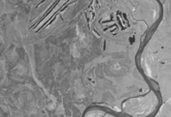
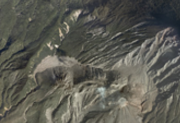
DTM AND ORTHOPHOTO MAPPING OF RAYONG
| Project Summary | : | Orthophoto Mapping |
| Description | : | Aerial Triangulation, DTM 40 meter and Digital Orthophoto resolution 30 cm. and GIS feature layer cover area 288 km2 |
| Sensor | : | DMC-1 |
| Detail | : | Scale of Orthophoto Mapping 1 : 4,000 |
| Country | : | Rayong, Bangkok |
| Time frame | : | 2013 |

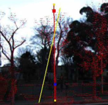
STREET TREE SURVEY PROJECT
| Project Summary | : | Street Tree Data Collection with PPS. |
| Description | : | The survey project requires height, perimeters, area information and kind. Surveyor will perform field survey for the detail of trees along each route. |
| Sensor | : | Lady Bug 360 Panorama |
| Detail | : | Final, Creation of Video Data, Survey Map and Inventory |
| Country | : | Japan |
| Time frame | : | 2012 |
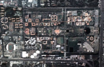
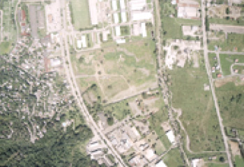
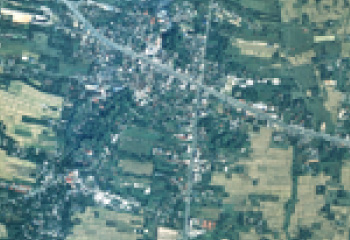
DTM AND ORTHOPHOTO MAPPING
OF THAMMASART UNIVERSITY
| Project Summary | : | Orthophoto Mapping for analyzed and planned flood protection. |
| Description | : | Aerial Triangulation, DTM 40 meter and Digital Orthophoto resolution 30 cm. and GIS feature layer cover area 4 km2 |
| Sensor | : | DMC-1 |
| Detail | : | Scale of Orthophoto Mapping 1 : 4,000 |
| Country | : | Pathumthani, Bangkok |
| Time frame | : | 2012 |
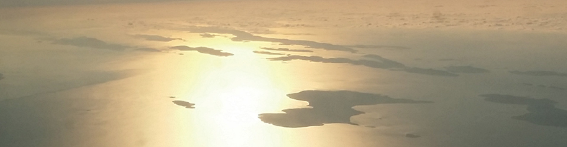
CHAO PHRAYA RIVER BASIN FLOOD CONTROL PROJECT
| Project Summary | : | Chao Phraya River Basin Flood Control Project Lidar Survey and Orthophoto Mapping. |
| Description | : | Airborne Laser Scanning and Orthophoto data creation area of Chao Phraya River Basin Flooded Region: 24,590 km2 |
| Sensor | : | ALS50-II, 60, 60II and RCD 105 |
| Detail | : | Orthophoto GSD 0.5 m., Lidar data resolution interval is 2 m. |
| Country | : | Thailand |
| Time frame | : | 2011-2012 |
PREPARATION OF ORTHOPHOTOS SCALE 1:10,000
IN THE REPUBLIC OF CAMEROON
| Project Summary | : | Aerial Triangulation, DTM 100 meter and Digital Orthophoto resolution 50 cm. |
| Description | : | Cover area 6,912 km2 in Cameroon |
| Sensor | : | UltraCam X |
| Detail | : | Scale of Aerial photos 1/25,000 |
| Country | : | Cameroon |
| Time frame | : | 2011 |
Ministry of lands, forestry & mines Ghahna land
administration project the republic of Ghana
| Project Summary | : | Scanning film, aerial triangulation, DTM, Digital Ortho photo and Contour 2 meter |
| Description | : | Cover 15,070 km2 of Ghana |
| Sensor | : | RC 30 and IMAO DIGICAM 39H |
| Detail | : | Total 13,286 aerial photos |
| Country | : | The republic of Ghana |
| Time frame | : | 2009 |
DIGITAL TERRAIN MODEL MAP OF NETHERLAND
| Project Summary | : | DTMaster program for correctly modify DTM |
| Description | : | Digital Terrain Model Map cover Area 41,500 km2 all of Netherland |
| Sensor | : | Lidar |
| Detail | : | DTM interval 5 meters. |
| Country | : | Netherland |
| Time frame | : | 2009 |
Engineer mapping and surveying services in Singapore
| Project Summary | : | Ortho photo project of US base camp in Singapore |
| Description | : | Making Digital Ortho photography of Singapore |
| Sensor | : | UltraCAM-D |
| Detail | : | Ortho Photo 5cm GSD |
| Country | : | Singapore |
| Time frame | : | 2008 |
Photogrammetric Restitution, Orthophotographs, Maps and
Digital Vector OrthophotoMaps in the republic of Panama
| Project Summary | : | Stereo Plotting and Ortho photo project of PANAMA |
| Description | : | Making Digital Ortho photography of 2,600 km2 of PANAMA and cadastral topographical maps 417 km2. |
| Sensor | : | UltraCAM-D |
| Detail | : | RGB Ortho Photo 20cm GSD, Digital Topographical maps 1/1,000 scale |
| Country | : | PANAMA |
| Time frame | : | 2007-2008 |
Aerial Orthophoto Mapping (Old photography)
Kanchanaburi and Roi Ed (Forest Area) 1:4000
| Project Summary | : | Ortho photo project of Thailand |
| Description | : | Black & White Ortho Photo of 2 Are as, 2terms |
| Sensor | : | Many old film camera |
| Detail | : | Ortho Photo 30cm and 75cm GSD |
| Country | : | Thailand |
| Time frame | : | 2007-2008 |
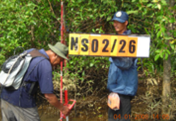
Survey of Mangrove boundary and Standard Mapping
in Trad Province
| Project Summary | : | to survey or mangrove boundary, preparing database and GIS and to print a standard Map 1:4,000 and 1:50,000 |
| Description | : | 882 Sq.Km Physical survey and Mapping, GIS and laser survey |
| Sensor | : | MOAC aerial photograhpy |
| Detail | : | 1:4,000 Mapping and GIS database |
| Country | : | Thailand |
| Time frame | : | 2007-2008 |
Film Duplicate Pilot Project
| Project Summary | : | to duplicate an old film (50 years ago) and scanning |
| Description | : | 34 Film rolls has been duplicated |
| Sensor | : | Duplicate Film and to scan as digital image |
| Detail | : | 1:4,000 Mapping and GIS database |
| Country | : | Thailand |
| Time frame | : | 2007-2008 |
Topographical map 1/50,000 in Georgia
| Project Summary | : | Stereo plotting project of Georgia |
| Sensor | : | Film Camera |
| Detail | : | Digital topographical maps 1/50,000 scale |
| Country | : | Georgia |
| Time frame | : | 2006-2007 |
CCDP_OP / Digital Orthophoto Procurement - CCDP-03-02
| Project Summary | : | Ortho photo product over an area of approximately 62,000 sq km in Western and Northern Cambodia |
| Description | : | Black & White Ortho Photo |
| Sensor | : | RC30 |
| Detail | : | Ortho Photo 50cm GSD |
| Country | : | Cambodia |
| Time frame | : | 2006 |
PREPARATION OF ORTHOPHOTOS SCALE 1:1,000,
OF SAN PEDRO SULA URBAN AREA, 290 KM2 DEPARTMENT
OF CORTES, REPUBLIC OF HONDURAS
| Project Summary | : | Ortho photo project of San Pedro Sula city in Honduras |
| Description | : | Making Ortho photo products by Scanning Aerial film |
| Sensor | : | Film Camera |
| Detail | : | RGB Ortho Photo 10cm GSD |
| Country | : | Honduras |
| Time frame | : | 2006 |
Procurement of Digital Images on a 1:20,000 scale
(resolution 0.40 m) and Preparation of Orthophoto
(resolution 0.50 m) of the Republic of Guatemala
| Project Summary | : | Ortho photo project of Guatemala |
| Description | : | Digital Ortho photography of 108,900km2 of GUATEMALA |
| Sensor | : | UltraCAM-D |
| Detail | : | RGB Ortho Photo 50cm GSD and CIR Ortho Photo 50cm GSD |
| Country | : | Guatemala |
| Time frame | : | 2005-2006 |
Nakhonnayok Laser survey and Orthophoto Mapping
(SatelliteCity) Project
| Project Summary | : | Physical survey, GIS, Lidar survey and orthophoto Mapping |
| Description | : | 882 Sq.Km Physical survey and Mapping, GIS and laser survey |
| Sensor | : | MOAC aerial photography and ALS50 (for laser survey) |
| Detail | : | 1:4,000 Mapping and GIS database |
| Country | : | Thailand |
| Time frame | : | 2005-2006 |
Cadastral Survey and Land Registration Project,
MON-1736/IS-APDOP-05/01
| Project Summary | : | Ortho photo project of Mongolia |
| Description | : | Making Digital Ortho photography of 5 cities in Mongolia |
| Sensor | : | RC-20 |
| Detail | : | Ortho Photo 15cm GSD |
| Country | : | Mongolia |
| Time frame | : | 2005 |