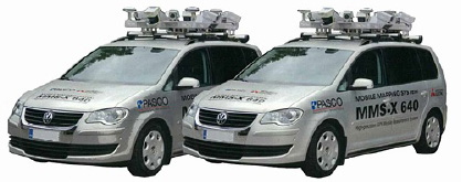
 MMS (Mobile Mapping System) is a laser equipment installed on automobile that used to survey and collect 3D co-ordinate information around the routes and road continuously by using 3D laser and digital camera. Mobile Mapping System shall cover technological applications, measuring equipment which can be movable be manpower and it can be installed on vehicle such as car, ship, and aircraft, high solution and precision of navigation system is basically installed on these vehicles to indicate location of vehicle and place as well as information recording time at any time which is called vehicle way, relations between vehicle and distance of sensors are installed together on vehicle. This relation shall indicate location and placing of sensors that created relations that linked to co-ordinate value of object in 3 dimensions of physical material to be measured, physical phenomenon that requires measurement. Furthermore, it also estimates type and characteristic of such object, therefore, Mobile Mapping System requires application of technology and comprehension of Global Navigation Satellite System (GNSS), Inertial Navigation System (INS), computer vision and close-range photogrammetry, frame and spherical video CCD imaging system and laser scanner / Lidar.
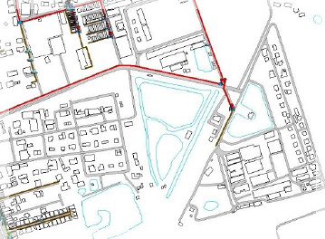
Mobile Mapping System (MMS)
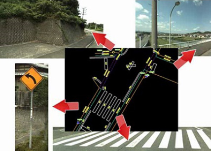
Road management by using MMS
- List of roads, topographic map, preparedness of basic map, survey road condition by using MMS (construction, objects that related to roads, ownership), conduct survey by using MMS and also apply it to use in public survey, and roadway diagram with no actual automobiles.
- Control objects that related to roads and list of road construction and also use MMS to consider objects which are components of road and road surface (signs, electric post, pipe, Guardrail, sound barrier). Isometric spots generate accurate location information which shall be very beneficial for creating management and control system of integrated roads infrastructure.
- Promoting construction design by using input information that obtained from the use of MMS, application of isometric spots obtained from MMS to prepare graph and cross-sectional diagram in any spot, using information obtained from laser survey with high precision, using isometric spots obtained from laser by overlapping each other from the lower part of object structure.
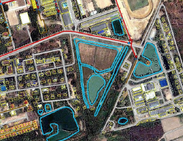
- Solution and prevention from disasters. In case, if there is a damage from road disaster such as slope collapse which can inspect damage by comparing information prior and after such disaster. PASCO (Thailand) Co., Ltd. use PADMS-Viewer and StereoMatching program for MMS function; these two programs are brought from PASCO (Japan) Co., Ltd.
PADMS-Viewer is the program that used input information that obtained from survey by vehicle that installed MMS system not so high level, mostly used to form image of roads, crossroads, signs, electric post and so on.
StereoMaching is the program that used input information obtained from survey by vehicle that installed MMS system likewise PADMS-Viewer. However, the difference is the installation is in high level which can cover 360 degrees and it is used to form slope image and being used effectively in high terrain areas.- Position survey by using GPS (Global Positioning System)
-
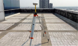
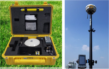
Static Survey Static survey is an operation that used 2 units or more numbers of signal receivers as one unit is placed at the designated spot and the other one shall be placed at the additionally searching spots and signal receivers must be placed not less than forty-five minutes. This method is used to search for relationship between the two spots which are approximately 20-30 kilometers apart in terms of distance.
-
Real Time Kinematic Survey: Real Time Kinematic (RTK) survey is the survey that obtained position coordinate immediately or real time in fieldwork by taking information from the two spots for collaborative processing by using radio waves in transmission-receiving information from the referent spot where its position has been recognized to the searching spot of signal receiving unit for processing and coordinate value shall be display immediately but the limited distance between the two working spots must not exceed 15 kilometers, besides, working efficiency shall rely on power of radio frequency used in such terrain. GPS survey is currently applied widely to other related surveys such as LIDAR survey and MMS survey.
-
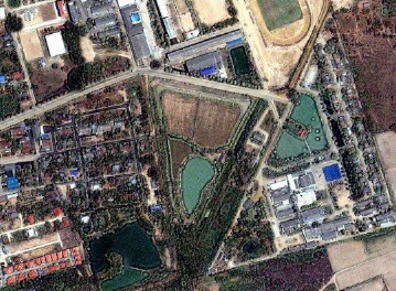
Providing service in Digitizing information obtained from aerial photograph or satellite images
It is an interpretation of aerial map by considering what appears on such images by using experiences and specialization of interpreter. The interpretation of aerial photograph shall be divided into 5 different categories which are land use, houses, roads, urban zone and forest zone.
-
Information preparation service by using GIS
It is the function that take the collected information which is obtained from photograph interpretation steps (either 2–dimension digitize or 3D Photogrammetry Stereo Plotting) to combine with additional information obtained from field survey in order to render the complete information system which is having a spatial relationship. For example, the house address must have spatial relation ship with house position appeared on the map.